

Geophysical Engineer Prof. Dr. Övgün Ahmet Ercan made a statement on his social media account.
21 PROVINCES RANKED
Drawing attention to the earthquake reality in Turkey, Ercan used the following expressions;
“Turkey's safest leading provinces in terms of destructive earthquakes: Kırklareli, Zonguldak, Kastamonu, Sinop, Samsun, Giresun, Ordu, Trabzon, Rize, Artvin, Mardin, Siirt, Batman, Ş.Urfa, Mersin, Antalya, Konya, Karaman, Niğde, Nevşehir, Ankara.”
Turkey's safest leading provinces in terms of destructive earthquakes: Kırklareli, Zonguldak, Kastamonu, Sinop, Samsun, Giresun, Ordu, Trabzon, Rize, Artvin, Mardin, Siirt, Batman, Ş.Urfa, Mersin, Antalya, Konya, Karaman, Niğde, Nevşehir, Ankara.
- Prof. Dr. Övgün Ahmet Ercan (@ovgunaercan) September 6, 2023
WHICH DISTRICTS ARE THE MOST RISKY IN ISTANBUL?
The earthquake map of Istanbul divides the earthquake-prone areas of the city into three categories: low, medium and high risk.
Low-risk districts and neighborhoods in Istanbul are Pendik, Kadıköy, Kartal, Ümraniye, Şile, Üsküdar, Darıca, Erenköy, Çengelköy, Suadiye, Altunizade, Polonezköy, Eminönü, Rumelihisarı, Adalar, Beşiktaş, İçerenköy, Sarıyer, Nişantaşı, İstinye, Gültepe, Kağıthane, Taksim, Arnavutköy, Şişli and Levent.
Moderately risky districts and neighborhoods in Istanbul are Üsküdar Sinkhole, Tarabya Sinkhole, Tophane, Çayırbaşı Sinkhole, the embankments in Ortaköy, Kurbağalıdere, Alibeyköy, Moda Coast, Silivri, Fatih, Gümüşyaka and Topkapı.
Areas in Istanbul at high risk of earthquakes are Zeytinburnu, Küçükçekmece, Florya, Esenkent, Ispartakule, Ambarlı, Avcılar and Haramidere.
ISTANBUL'S MOST EARTHQUAKE-PRONE REGIONS
According to the statement made by earthquake experts; Beyoğlu and Fatih districts are the oldest districts in terms of structure in Istanbul. These regions are seen as the places that will be most affected by the earthquake.
Considering the age of the buildings in Istanbul, Fatih (Historical Peninsula), which ranks second after Beyoğlu as the oldest district, stands out as the district that will be most affected by the earthquake.
In addition to Fatih, Zeytinburnu, Bakırköy, Florya, Menekşe-Kanarya and Cumhuriyet neighborhoods of Küçükçekmece, Avcılar, Pekmez and Pinarkent neighborhoods of Gürpınar in Beylikdüzü, Devebağırtan region of Büyükçekmece, Kumburgaz and Silivri, as well as Tekirdağ and Marmara Ereğlisi will be severely affected by the earthquake.
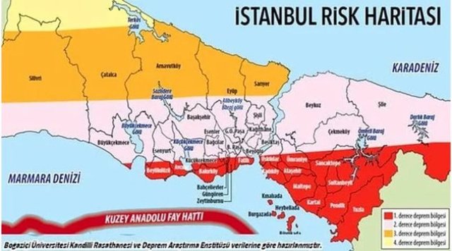
ISTANBUL EARTHQUAKE RISK MAP
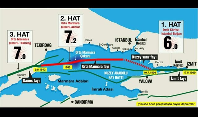
The risk map in Istanbul, where the North Anatolian Fault line is located, is as in the image. Istanbul Metropolitan Municipality last updated the analysis of 39 districts in Istanbul in 2019.
Istanbul Metropolitan Municipality prepared the project for updating earthquake loss estimates for Istanbul in 2019. Earthquake loss estimates obtained for a 7.5 magnitude earthquake scenario in Istanbul, superstructure and infrastructure damages, loss of life and number of injured estimates, road closure analyses and temporary shelter needs were calculated for each district customized for districts and related maps were produced.
EARTHQUAKE-RESISTANT DISTRICTS ON THE EUROPEAN SIDE
Beyoglu
Besiktas
Sisli
Kagithane
Gaziosmanpasa
Important part of Esenler
Kemerburgaz - Gokturk
Sultanbeyli
High areas of Beykoz far from the coast
A section of Maltepe far from the coast
Cekmekoy
Sultangazi
Most of Başakşehir
A part of Sarıyer far from the coast
Arnavutkoy
Maslak
Alibeykoy
DISTRICTS AND DISTRICTS WITH MEDIUM EARTHQUAKE RISK IN ISTANBUL
Besiktas,
Ortakoy Dereboyu,
Istinye pit,
Tarabya pit,
Uskudar pit,
Beylerbeyi pit,
Kucuksu pit,
Paşabahçe-Beykoz pit,
Topkapi,
Bakirkoy,
Garden houses,
Merter,
Sirinevler (part of),
Halkali,
Nakkasdere,
Esenkent,
Omerli,
Buyukcekmece,
Tepecik (Tepecik, Akören and the southern part of Pomak),
Selimpasa,
Silivri,
Bag,
Silveryaka,
Kavaklı,
Yakuplu,
Esenyurt,
Hunters,
Ambarli,
Firuzkoy,
Küçükçekmece,
Florya, Yesilkoy,
Atakoy and Zeytinburnu,
Meadowhead pit,
Karakoy, Tophane,
Salıpazarı, Ortaköy (in-fill sections),
Job,
Alibeykoy,
Sütlüce,
Balat,
Kasımpaşa and the coastal part of Güngören,
Kadıköy (Kurbagalidere),
Fashion (the part facing the sea),
Kucukyali,
Eagle (Rahman division),
Tuzla (stream part),
Dilovasi,
Eminönü (Cankurtaran, Şehzadebaşı, Fatih, Çarşamba, the part south of Edirnekapı).
WHICH DISTRICTS IN ISTANBUL ARE THE MOST VULNERABLE TO EARTHQUAKES?
Zeytinburnu Ayamama Creek,
Nakkaşdere alluvium east of Küçükçekmece Lake,
Azaplı region (low-lying areas of Altınşehir),
Ispartakule (western parts of Alibey Peninsula),
Canary (Firuzköy coast),
Esenkent,
Avcılar (shores facing Küçükçekmece Lake and Marmara Sea),
Ambarlı and Haramidere,
The parts where Atakoy is located,
Florya (landslide areas to the west) Küçükçekmece coast.